


The vertical cirrus cloud structure during the two time periods was very complex. From 18:08-19:24 GMT, there was mostly scattered optically thin cirrus clouds which occurred both individually and in layers as seen in Figure 1. The lowest level clouds occurred at a height of 6 km while the highest cirrus clouds were seen at 10 km. The uppermost clouds occurred at the tropopause and consisted of ice crystals as seen by the specular reflection from the layer (as described in Section 3.1.1). The majority of the cirrus clouds occurred between the heights of 6 and 9 km, often overlapping at different levels. Occasionally, a precipitating cirrus cloud advected into the region at a height of 8 km between 25 km north and 25 km south of the VIL. These precipitating cirrus clouds are seen in the bottom half of Figure 1, the along wind scan. Virga fell approximately 2 km from these clouds before evaporating. Most of the cirrus clouds during this time period were seen north of the VIL.
For the second time period, 19:29 to 21:20 GMT, the cirrus clouds were more widespread. At 19:30 GMT, the cirrus clouds were similar to the earlier period with scattered thin cirrus clouds throughout most of the region. Again, these clouds often occurred in multiple layers. At 19:40 a precipitating cirrus cloud layer at a height of 8 km between 20 and 40 km to the south of the VIL moved into the region (Figure 7). This layer lasted for about one hour with virga falling 1 to 2 km below the precipitating layer. At 20:30 GMT, an extensive precipitating cirrus cloud deck advected into the region between 20 km south and 30 km north of the VIL (Figure 8). The precipitating layer occurred between heights 8.5 and 9.5 km with ice crystals falling to a height of 6 km. As the time period progressed, the cirrus cloud deck increased in optical thickness. Both to the north and south of the cirrus cloud deck multiple layers of thin cirrus clouds were seen. Also in Figure 8, the attenuation of the VIL signal can be seen. This loss of signal occurs between 7 km and 9 km further than 40 km north of the VIL and further than 30 km south of the VIL. The cirrus cloud layer at the tropopause was visible until 20:00 GMT.
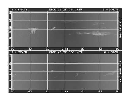
Figure 7: Typical cirrus clouds seen from 19:29 to 20:15 GMT.
The x-axis is the distance from the VIL and the y-axis is altitude.
The top picture is a cross wind scan, scanning from the North (357 )
to the South (177
)
to the South (177 ). The bottom picture is an along wind scan, scanning West
(267
). The bottom picture is an along wind scan, scanning West
(267 ) to East (87
 ). The scan times are given in local time (CST).
Both scans show the cirrus cloud variability.
). The scan times are given in local time (CST).
Both scans show the cirrus cloud variability.
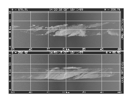
Figure 8: Same as Figure 7 but for the time period of 20:30 to 21:20 GMT.
The precipitation from the cirrus clouds is easily seen in the along wind scan.
Note the effects of attenuation at the longer slant paths in
the bottom scan between 20 and 60 km West of the VIL near a height of
8km (also between 40 and 60 km East of the VIL at the same heights).