


Many previous measurements of the cirrus cloud morphology have been made using ground based vertically pointing instruments. These cloud measurements were aligned along the wind due to the advection of atmospheric structure over the instrument. Attempts by these point measurements to represent the general cirrus cloud structure relied on the uniformity of the clouds throughout the area under consideration. If the cirrus clouds varied significantly across the wind, then point measurements along the wind could not be used to represent the large scale cirrus cloud structure. The VIL cirrus cloud scans were used to observe the cirrus cloud structure in an atmospheric mesoscale volume. Cirrus cloud structural variations within this volume were used to determine the cirrus cloud variability and the sampling errors associated with cirrus cloud point measurements.
During CRSPE, the VIL scanned a volume of the atmosphere containing cirrus clouds. Each cross wind scan showed a two dimensional picture of the cirrus clouds. A time series of cross wind scans revealed the three dimensional cloud structure where it was assumed that there was no time variation during the advection of the cirrus clouds by the wind. Once a cirrus cloud threshold value was chosen for the VIL data within the volume, the cloud cover percentage and horizontal structure within the mesoscale volume could be calculated from consecutive cross wind scans. A cirrus cloud threshold denotes the smallest backscattered signal considered to be from a cirrus cloud. A threshold value was determined by examining a histogram of the VIL backscattered signal from the cirrus cloud heights, 6 to 11 km, for the time periods under consideration (Figure 2). A clear distinction between cirrus cloud backscatter and the background aerosol backscatter was seen. The range squared, energy normalized VIL data greater than the chosen threshold value (3.48 in Figure 2) was assumed to have been backscattered from the cirrus cloud ice crystals. Backscatter values smaller than the threshold were considered to be the result of non-cirrus aerosols and molecules. Since the threshold was chosen from a series of VIL cross wind scans, the cirrus cloud threshold value was constant for the whole data set. Only data within a horizontal distance of 30 km from the VIL was used in the cirrus cloud determination. The 30 km distance was chosen to retain a consistent threshold value throughout the data set. When the distance to the scatterers becomes large, the VIL signal becomes instrument limited causing the thinner cirrus clouds to go undetected. The calculations of the cirrus cloud structure are done in the following subsections.
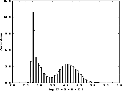
Figure 2: 50 point histogram of the VIL signal from the cirrus cloud
heights, 6 km to 11 km. The
x-axis is the logarithm of the VIL range square corrected, energy
normalized signal. The y-axis is the percentage of points in each
interval. Notice the local minimum near 3.5. This shows a clear
separation between the cirrus cloud ice crystal backscatter and the background
aerosol and molecular backscatter at 1064 nm.