


The VIL is an elastic backscatter lidar which measures the three dimensional atmospheric structure. This instrument scans the atmosphere in both azimuth and elevation angles using a wavelength of 1064 nm. The VIL typically scans the atmospheric structure in two directions, parallel and perpendicular to the wind direction at the cirrus cloud heights. A series of cross wind scans enables a three dimensional reconstruction of the cirrus clouds. This three dimensional view, using the advection of the clouds by the wind as the third dimension, reveals the cirrus mesoscale cloud morphology.
For CRSPE, the
VIL scanned the atmosphere at approximately  a second with a time
resolution of 85 seconds between consecutive scans. A typical VIL cirrus
scan can be seen in Figure 1. The top cloud picture is a cross
wind scan and the bottom picture is an along wind scan. The cross wind scan
started at 357
a second with a time
resolution of 85 seconds between consecutive scans. A typical VIL cirrus
scan can be seen in Figure 1. The top cloud picture is a cross
wind scan and the bottom picture is an along wind scan. The cross wind scan
started at 357 (north), scanned overhead, and ended at 177
 .
This is called the cross wind scan because it was almost perpendicular
to the wind direction at the cirrus cloud heights (the wind was approximately
from the west-northwest at the cirrus cloud heights). After the completion
of the cross wind scan, the azimuth angle of the system was rotated 90
.
This is called the cross wind scan because it was almost perpendicular
to the wind direction at the cirrus cloud heights (the wind was approximately
from the west-northwest at the cirrus cloud heights). After the completion
of the cross wind scan, the azimuth angle of the system was rotated 90 to begin the along wind scan. This scan started at 267
 , scanned
overhead, and completed at 87
, scanned
overhead, and completed at 87 (toward the east). This X scan
was performed almost continuously for a three hour
time period (18:08 - 21:20 GMT). For CRSPE,
the VIL scanned 120 km of the atmosphere in the horizontal extent
with a maximum distance between data points of 60 m.
(toward the east). This X scan
was performed almost continuously for a three hour
time period (18:08 - 21:20 GMT). For CRSPE,
the VIL scanned 120 km of the atmosphere in the horizontal extent
with a maximum distance between data points of 60 m.
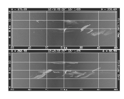
Figure 1: Typical cirrus clouds seen from 18:08 to
19:24 GMT. The x-axis is the distance from the VIL and the y-axis is height.
The top picture is a cross wind scan; scanning from the North (357 )
to the South (177
)
to the South (177 ). The bottom picture is an along wind scan, scanning
from West (267
). The bottom picture is an along wind scan, scanning
from West (267 ) to East (87
 ). The scan times are given in local
time (CST). Both scans show the cirrus cloud variability. Precipitating
cirrus clouds are seen in the along wind scan.
). The scan times are given in local
time (CST). Both scans show the cirrus cloud variability. Precipitating
cirrus clouds are seen in the along wind scan.
The two VIL scan directions allow for two different views of the cirrus clouds. Precipitation from the cirrus clouds can be seen in the along wind scan due to the wind shear at the cirrus cloud heights. This can be seen in the bottom picture in Figure 1. The slope of the cirrus clouds with distance results from wind shear. The along wind scan also shows the cirrus clouds which will be advected over the VIL at later times. The cross wind scans show the cirrus cloud structure perpendicular to the wind. The cirrus clouds seen in the cross wind scans during this experiment usually had a higher degree of spatial variability than those observed in the along wind scans. These variations across the wind would not be seen by a vertically pointing ground based instrument.