The VAS, a radiometer on the GOES satellite, detects
infrared radiation in 12 spectral bands that lie between 3.9 and 15  m at
7 km or 14 km resolution (depending on the detector used) while also measuring
at visible wavelengths with a 1 km resolution. The infrared
channels have a 7 km resolution at nadir above the equator and a 10 km
resolution viewing the atmosphere above Madison, Wisconsin. The upwelling
longwave radiation in the 11
m at
7 km or 14 km resolution (depending on the detector used) while also measuring
at visible wavelengths with a 1 km resolution. The infrared
channels have a 7 km resolution at nadir above the equator and a 10 km
resolution viewing the atmosphere above Madison, Wisconsin. The upwelling
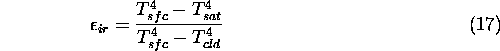
longwave radiation in the 11  m channel was used to determine the
cirrus cloud infrared emissivity and
optical depth. The upwelling radiation was converted into a temperature for
each pixel using Planck's Radiation Law. The cirrus infrared emissivity
was then calculated using the following equation:
m channel was used to determine the
cirrus cloud infrared emissivity and
optical depth. The upwelling radiation was converted into a temperature for
each pixel using Planck's Radiation Law. The cirrus infrared emissivity
was then calculated using the following equation:
where:
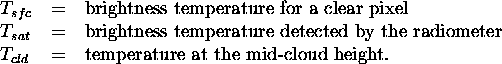
 used in Equation 17 was determined from
a satellite pixel where it was assumed that no clouds were present
(a clear pixel). Clear pixels were determined with help from the VIL since
subvisible cirrus clouds were present during the experiment.
The cirrus mid-cloud heights were calculated from the
VIL cross wind scans. The cloud temperatures associated with the cirrus
mid-cloud height were determined from coincident rawinsonde measurements. The
rawinsondes were launched from the HSRL site during this experiment.
used in Equation 17 was determined from
a satellite pixel where it was assumed that no clouds were present
(a clear pixel). Clear pixels were determined with help from the VIL since
subvisible cirrus clouds were present during the experiment.
The cirrus mid-cloud heights were calculated from the
VIL cross wind scans. The cloud temperatures associated with the cirrus
mid-cloud height were determined from coincident rawinsonde measurements. The
rawinsondes were launched from the HSRL site during this experiment.