
Return to Description. Return to Index.
Antti K. Piironen, Paivi Piironen, Walter Wolf, Edwin W. Eloranta
Three-dimensional aerosol backscatter cross section fields are derived from Volume Imaging Lidar (VIL) and High Spectral Resolution Lidar (HSRL) data. While the VIL is a scanning lidar providing high spatial resolution data of atmospheric scatterers, external information is needed for resolving the backscatter cross section from the data. Therefore, HSRL measured backscatter cross-sections are used to calibrate the VIL measurements. The method is discussed in detail later in this document.
The high sensitivity of the VIL allows observations of inhomogeneities in the natural aerosol backscatter. The signal incident on the receiver is described by the single-scatter lidar equation [1,2]
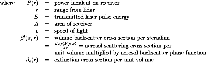
There are two unknowns, backscatter cross section  and
extinction cross section
and
extinction cross section  in the equation (1)
and only one measurement of backscattered signal power
in the equation (1)
and only one measurement of backscattered signal power  .
Therefore, additional information is needed to solve the equation for
backscatter.
.
Therefore, additional information is needed to solve the equation for
backscatter.
This analysis uses backscatter cross sections measured with the HSRL for calibration of the VIL data. An aerosol layer that stays nearly constant with time is selected as a calibration target. Since HSRL operates at 532 nm wavelength while VIL at 1064 nm, aerosol and molecular backscatter values for the VIL are calculated from the HSRL values by dividing them by 2 and 16, respectively. We assume that the backscatter cross section varies as 1/wave_length for aerosol scattering. When this scaled backscatter cross section is used with HSRL measured average phase function, the equation (1) can be solved for the backscatter. This method provides an approximate calibration for the VIL data.
The data volumes have been produced from Volume Imaging Lida r (VIL) multiple cirrus cloud scans. These scans were aligned to be nearly perpendicular to the wind. Consecutive cirrus cloud scans enable a reconstruction of the cirrus clouds within a volume when the wind speed and direction are known. These reconstructions assume that the cirrus cloud structure does not change during the time it takes the cloud to drift across the volume. Each VIL profile is converted into an approximate backscatter profile. Then each data point is moved according to wind to provide snapshot volume at the chosen reference time. Local radiosonde launches are performed to provide wind information.
The provided backscatter volumes represent total backscatter cross section at 1064 nm wavelength. There are some features that the user should be aware of:
Aerosol Backscatter Cross Section Volumes Derived from Volume Imaging Lidar and High Spectral Resolution Lidar Data from August 24 to December 8, 1995
This document was generated using the LaTeX2HTML translator Version 95 (Thu Jan 19 1995) Copyright © 1993, 1994, Nikos Drakos, Computer Based Learning Unit, University of Leeds.
The command line arguments were:
latex2html -split 0 readabcs.tex.
The translation was initiated by Antti Piironen on Fri Jan 5 10:18:06 CST 1996