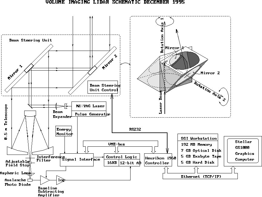
Figure 1: VIL Schematic Dec. 1995.
Return to the Index.
The Volume Imaging Lidar (VIL) is an elastic aerosol backscatter lidar designed to image the four-dimensional structure of the atmosphere [1]. Figure 1 shows a block diagram of the system.
Figure 1: VIL Schematic Dec. 1995.
The transmitter employs a pulsed Nd:YAG laser.
The receiver consists of
a telescope, interference filter, and avalanche photo diode.
Scanning is performed using a fast, computer controlled
beam steering unit
consisting of
two flat rotating mirrors mounted at 45 angles on the optical axis
of the transmitter-receiver system.
Realtime control and data acquisition are controlled by an Intel i960
microcontroller on VME bus.
An interactive user interface and graphical real time displays are
perfomed using Silicon Graphics Indigo II workstation.
The system is mounted in a
semi-trailer, that has
a water chiller and air conditioning to provide an adequate environment
for the lidar and electronics.
Only an external AC-power source is required for
a full field operation.
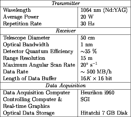
Table 1 summarizes the system specifications
during the FIFE program.
angles on the optical axis
of the transmitter-receiver system.
Realtime control and data acquisition are controlled by an Intel i960
microcontroller on VME bus.
An interactive user interface and graphical real time displays are
perfomed using Silicon Graphics Indigo II workstation.
The system is mounted in a
semi-trailer, that has
a water chiller and air conditioning to provide an adequate environment
for the lidar and electronics.
Only an external AC-power source is required for
a full field operation.
Table 1 summarizes the system specifications
during the FIFE program.
The high sensitivity of the VIL allows observations of inhomogeneities in the natural aerosol backscatter. The signal incident on the receiver is described by the single-scatter lidar equation [2,3]
The dynamic range of the digitized signal is increased by amplifying the detected signal with a logarithmic amplifier. The data acquisition system has a 10 MHz sampling rate and a 12-bit digitizing resolution. Each backscatter profile is energy-normalized to compensate the output energy variations of the laser and corrected for inverse range-squared dependence. This signal is expressed as
Finally, the signal is saved in a compressed form on an optical
disk for later analysis
[1].
Since molecular absorption is
small compared to aerosol extinction at the 1064 nm
operation wavelength,
the measurement range depends mainly on the aerosol distribution and
range-squared dependence of the detected backscatter.
The high laser power, large telescope area, and
wide dynamic range of the receiver enable
detection of cirrus clouds up to 100 km from the lidar,
and boundary layer aerosols up to 30 km in a clear atmosphere.
Although the VIL can scan the whole sky,
special scanning patterns are used for different atmospheric studies.
For boundary layer studies, the VIL usually scans a 40 azimuthal sector and 15
 elevational angle range.
Typically, this scan employes a 15 m
radial, 0.5
elevational angle range.
Typically, this scan employes a 15 m
radial, 0.5 azimuth, and 0.33
 elevation angle resolution.
Figure 2 illustrates a typical
boundary layer volume scan pattern.
The VIL devotes about 3 minutes to record approximately five million
data points in this 100km
elevation angle resolution.
Figure 2 illustrates a typical
boundary layer volume scan pattern.
The VIL devotes about 3 minutes to record approximately five million
data points in this 100km volume.
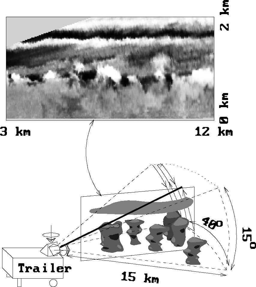
Figure 2: A VIL boundary-layer scan.
The graph on the top shows a Range Height Indicator plane
calculated from the backscatter profiles of one elevational sweep;
the brighter areas indicate increased scattering from boundary
layer aerosols.
This document was generated using the LaTeX2HTML translator Version 95 (Thu Jan 19 1995) Copyright © 1993, 1994, Nikos Drakos, Computer Based Learning Unit, University of Leeds.
The command line arguments were:
latex2html -init_file web_init_paper -split 0 vil.tex.
The translation was initiated by Antti Piironen on Mon Apr 8 09:40:43 CDT 1996

