Vis5D Movies of VIL Data
Return to the Index.
Before Viewing
- We have an example set of Volume Imaging Lidar images and data available in
Vis5D format.
Vis5D is a program to view 3D time dependent data sets that runs
only on UNIX computers.
In order to view the following files, you have to
install a Vis5D viewer into your machine from the
Vis5D Web site.
Then view the Vis5D images directly off from our Web site or from the CD-ROM.
-
- Note for the Netscape users: For easy viewing of the movies,
modify your .mime.types to include line:
- application/vis5d v5d
and your .mailcap to include line:
- application/vis5d; vis5d %s .
Warning: When viewing these files with the web browser, it loads the
whole file into a temporary file on your hard disk before starting Vis5D to
view it.
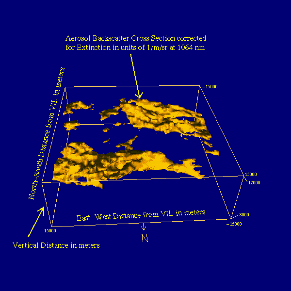
Volume Description
- The sample data volume has been produced from
Volume Imaging Lidar
(VIL) cirrus cloud scans. These scans were aligned to be nearly
perpendicular to the wind. Consecutive scans enable a reconstruction of the
cirrus clouds within a volume when the wind speed and direction are known. The
center scan in the volume is not position corrected but the other scans in the
volume are shifted by the wind speed and direction to the position at which
these clouds were at the time of the center scan. Consecutive volumes are
created by choosing a new center scan later in time with the corrections for
the other scans in the volume. Each volume is centered on the Lidar site.
The reconstructions assume that the cirrus cloud structure does not change
during the time it takes the cloud to drift across the volume. External
information is needed to calculate the backscatter cross section from the
uncalibrated VIL data. Three-dimensional backscatter cross section fields are
derived from Volume Imaging Lidar (VIL) using an approximate calibration from
simultaneous High Spectral Resolution Lidar (HSRL) data. For more information
how these volumes are created, read this
link.
- These volumes in the data and movie files are in the form of a 10-based
logarithmic value of the aerosol backscatter cross section [1/m/sr] with
extinction correction at 1064 nm. The extinction cross sections can be
derived by dividing the backscatter cross section by the backscatter phase
function. The average backscatter phase function measured by the HSRL in
cirrus clouds is 0.028 1/sr. Additional information on the VIL and HSRL is
available on our Web site on
the Internet.
- Following image gives a brief description of a Vis5D graphics window.
-
Sample Volume
- A Vis5D data file
(size 15 MB) generated from lidar data
obtained on September 16, 1995 during Lake Koshkonong
field experiment
is provided as an example. We have more Vis5D data volumes in our archives.
If you are interested in them, contact
Ed Eloranta.
UW Lidar // March 29, 1996 // wolf@lidar.ssec.wisc.edu