


From Mie theory, in the limit of completely absorbing
particles at 10.6  m which are also large compared to visible
wavelengths, the ratio of the visible scattering efficiency to the
infrared absorption efficiency
is expected to be 2:1. This ratio (
m which are also large compared to visible
wavelengths, the ratio of the visible scattering efficiency to the
infrared absorption efficiency
is expected to be 2:1. This ratio ( ) has been
used to describe the radiative properties of cirrus cloud
ice crystals (Minnis (1991), p. 83). This efficiency ratio
can also be written as the ratio of the visible scattering optical depth
to the infrared absorption optical depth times an extinction efficiency ratio
(
) has been
used to describe the radiative properties of cirrus cloud
ice crystals (Minnis (1991), p. 83). This efficiency ratio
can also be written as the ratio of the visible scattering optical depth
to the infrared absorption optical depth times an extinction efficiency ratio
(  ). Since the
ice crystals were assumed to be large compared to both visible and infrared
wavelengths, the extinction efficiency ratio was one and the
optical depth of cirrus clouds at the two wavelengths are directly related. A
relationship of this type allows for a simple parameterization for the
cirrus cloud optical properties at the two wavelengths. Measurements of the
optical depth at one wavelength allows for the optical properties of the
cirrus clouds at the second wavelength to be calculated.
Previous modeled ratios for cirrus cloud
). Since the
ice crystals were assumed to be large compared to both visible and infrared
wavelengths, the extinction efficiency ratio was one and the
optical depth of cirrus clouds at the two wavelengths are directly related. A
relationship of this type allows for a simple parameterization for the
cirrus cloud optical properties at the two wavelengths. Measurements of the
optical depth at one wavelength allows for the optical properties of the
cirrus clouds at the second wavelength to be calculated.
Previous modeled ratios for cirrus cloud
 range from 1.8:1
to 4:1 (Minnis et al. (1993), p. 1281).
range from 1.8:1
to 4:1 (Minnis et al. (1993), p. 1281).
Few coincident measurements of the cirrus clouds optical depth at both infrared and visible wavelengths have been made to test the optical depth ratio determined from theory. Platt et al. (1980) made simultaneous measurements of cirrus clouds using a ground based lidar and a satellite based infrared radiometer. The ratio of the optical depths at the two wavelengths measured by Platt was less than 2. The cirrus clouds were observed within a 10 km by 10 km volume using a single channel lidar. The visible optical depths were determined with the aid of a calculated backscatter to extinction ratio for the cirrus clouds. Measurements of cirrus cloud optical properties were also made during a FIRE IFO using ground based and satellite measurements. The mean ratio of the visible scattering optical depth to infrared absorption optical depth for the cirrus clouds observed during the IFO was 2.13 (Minnis et al. (1990)). The cirrus clouds were observed using a satellite based visible radiometer. The visible optical depths were calculated from these visible radiances using an iteration technique where the cloud albedo was linearly related to the cosine of the solar zenith angle. The cloud cover percent and cloud type within each pixel had to be known.
A method is described in this section to calculate the area averaged ratio
of the  for cirrus clouds.
This method used
VIL data calibrated using the method described in Section 4 and the
VAS 11
for cirrus clouds.
This method used
VIL data calibrated using the method described in Section 4 and the
VAS 11  m radiance measurements. The visible scattering optical
depths were determined by integrating the VIL calibrated visible
extinction cross sections (calculated using
Equations 12 and 14) in distance along a
ray from the GOES point of view.
The infrared absorption optical depth was calculated from the
VAS infrared emissivities which were determined using Equation 17.
The mid-cloud height used in Equation 17 was determined by
the VIL and the temperature at the mid-cloud height
was measured with the rawinsonde.
m radiance measurements. The visible scattering optical
depths were determined by integrating the VIL calibrated visible
extinction cross sections (calculated using
Equations 12 and 14) in distance along a
ray from the GOES point of view.
The infrared absorption optical depth was calculated from the
VAS infrared emissivities which were determined using Equation 17.
The mid-cloud height used in Equation 17 was determined by
the VIL and the temperature at the mid-cloud height
was measured with the rawinsonde.
The VAS on GOES imaged the atmosphere over Wisconsin
once every half hour. To compare the visible and infrared optical depths,
the VIL mesoscale volume was viewed from the position of the GOES satellite.
This was possible because the VIL imaged the cirrus clouds throughout
the mesoscale volume. The resulting VIL volume can be viewed from
any direction because the
 are known at each data point within the volume
(calculated from the
are known at each data point within the volume
(calculated from the  using the bulk backscatter
phase function as described earlier).
For an accurate lidar and satellite
cirrus cloud comparison, the VIL cirrus cloud volume was
broken into one hour time periods around each VAS picture. To
match the cirrus clouds in the GOES infrared image to the picture
created from the VIL data, the clouds viewed by the VIL
were shifted in position to the
point where they would have occurred at the time of the VAS picture.
The translation of the cirrus clouds was made under the assumptions
that the cirrus clouds were advected at the speed of the wind at their
heights and that the cirrus clouds did not change over a half hour period.
The magnitude and direction of the shift
was a result of the wind speed and direction at each cirrus cloud level
and the time difference between the scan where the cirrus clouds
occurred and the VIL scan at the time of the VAS snapshot.
using the bulk backscatter
phase function as described earlier).
For an accurate lidar and satellite
cirrus cloud comparison, the VIL cirrus cloud volume was
broken into one hour time periods around each VAS picture. To
match the cirrus clouds in the GOES infrared image to the picture
created from the VIL data, the clouds viewed by the VIL
were shifted in position to the
point where they would have occurred at the time of the VAS picture.
The translation of the cirrus clouds was made under the assumptions
that the cirrus clouds were advected at the speed of the wind at their
heights and that the cirrus clouds did not change over a half hour period.
The magnitude and direction of the shift
was a result of the wind speed and direction at each cirrus cloud level
and the time difference between the scan where the cirrus clouds
occurred and the VIL scan at the time of the VAS snapshot.
To convert the VIL data within the volume into visible scattering
optical depths, a ray tracing technique was used to integrate the VIL
extinction cross sections between the satellite position and the ground.
Rays were traced to the ground for each
VIL area which had a resolution of 1.0 km by 1.0 km. The VIL extinction
cross sections were
integrated along each ray to determine the optical depth of the
cirrus clouds for each visible pixel. The pixels were then averaged
to create grids the size of the VAS infrared radiometer pixels, approximately a
10 km resolution above Madison, Wisconsin.
The resulting averaged visible scattering optical depths were
directly compared to the VAS infrared absorption optical depths calculated
using the following equation (where  is calculated in
Equation 17):
is calculated in
Equation 17):
The VAS infrared radiance satellite image was directly compared
to the VIL visible optical depth simulated satellite image. The VIL visible
optical depth image
was position shifted to achieve the best cloud correlation between the
two pictures to correct for cloud position errors in the VAS image
due to satellite registration errors (this correlation was done by eye).
A visible to infrared optical depth comparison was calculated for the pixels
with high cloud cover percentages. The resulting comparison is shown in
Figure 14. A line with a slope 2:1 is shown for reference.
It should be noted that this optical depth comparison was achieved using
an upper limit on  , not a limit on the attenuation correction
factor. This upper limit of
, not a limit on the attenuation correction
factor. This upper limit of  did not remove a significant
number of overcorrected data points which resulted from the attenuation
correction. This leads to some overestimations of the visible optical
depths especially at larger optical depths.
did not remove a significant
number of overcorrected data points which resulted from the attenuation
correction. This leads to some overestimations of the visible optical
depths especially at larger optical depths.
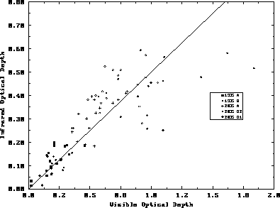
Figure 14: VIL visible scattering optical depths verses VAS infrared
absorption optical depths
for the same cirrus cloud pixels from 19:29 to 21:20 GMT on December 1, 1989.
The x-axis is the VIL visible scattering optical depths. The y-axis is
the VAS infrared absorption
optical depths. The different symbols represent different cirrus cloud types
described in the text.
In Figure 14, the optical depth ratio from different cirrus cloud types is represented by different symbols. The clouds labeled as '1935 A' were thin nonprecipitating cirrus clouds which often occurred in overlapping layers. The ratio for these clouds was close to 2:1 with a slight tendency for the ratio to be less than 2:1. An example of these clouds is seen in Figure 7 between 20 and 50 km to the north. The second cloud type, '1935 B', was a band of precipitating cirrus clouds occurring between 30 and 40 km south of the VIL in Figure 7. These clouds also show an optical depth ratio close to 2:1. Both of these cloud types had visible optical depths less than 0.5. The remaining sets of clouds were thick precipitating cirrus clouds where the optical depths often became large. Extensive virga fell from these optically thick cirrus clouds to a height of 6 km. The cirrus clouds described as '2035 A' were precipitating bands occurring ahead of a large cirrus cloud deck. The optical depth ratio for these clouds tended to be less than 2:1. A fourth type of ice cloud was labeled '2035 D2'. These were clouds in the center of a large precipitating cirrus cloud deck. The optical depth ratios for these clouds also tended to be less than 2:1. Some of the cirrus clouds were too optically thick for the VIL signal to penetrate at longer slant paths. This led to smaller than expected visible optical depths which resulted in a ratio of less than 2:1. The last group of cirrus were labeled '2035 D1'. This group consisted of three cirrus cloud cross wind scans within the large precipitating cloud deck which had vertically thin layers of high backscatter. The optical depth ratios for these clouds ranged from 2:1 to 3:1. Optical depth ratios greater than 2:1 can result from: specular reflection in the VIL data, pixel misalignments between the two images, incorrect averaging of the VIL data, instability in the VIL attenuation correction procedure, and smaller than expected scattering particles.
Specular reflection in the three cross wind scans could not have
caused the thin regions of high backscatter. The increased backscatter
layer extended over a horizontal range of 40 km. The ice crystal
orientation would have had to change with the VIL scan angle to cause specular
reflection for the whole range (which was highly unlikely). A second
possible error was the allocation of the cirrus clouds into
the different cirrus cloud pixels. This can result in
an increase or a decrease in the optical depth ratio depending on which
satellite pixel the cirrus clouds fell.
The magnitude of these allocation errors are currently under
investigation. Another
cause for an optical depth ratio greater than 2:1 could be the
result of the averaging
technique to produce the visible optical depths at the 10 km scale.
For each satellite pixel, the average infrared radiance was measured. This
was converted into an effective temperature which was then used to calculate
the infrared optical depth. The visible optical depths were produced at
a 1 km scale by averaging the extinction cross sections at each level
and then integrating them with height. The 1 km visible optical depth
pixels were then averaged together to produce a 10 km scale image. Since the
effect of the optical depth on the transmitted radiation was nonlinear,
the VIL extinction cross sections should have been averaged over the
10 km infrared
image. A probable error in the optical depth comparison was the instability
in the VIL attenuation
correction technique. This effect only becomes important
for the clouds with large optical depths since the corrections at the smaller
optical
depths were minimal. One last error could result if the scatterers were not
large compare to both the 11  m and 0.5
  m radiation. If the
particles were spherical and consisted of ice, then the scatterers with
radii between 0.1
m radiation. If the
particles were spherical and consisted of ice, then the scatterers with
radii between 0.1  m and 4
  m would cause an optical
depth ratio greater than 2:1.
m would cause an optical
depth ratio greater than 2:1.
Some other errors associated with this visible to infrared optical
depth comparison are scattering of the infrared wavelength
radiation by the cirrus cloud ice particles
(especially at larger infrared optical depths), the assumption that the
upwelling infrared radiation has a  dependence, and the attenuation of
the VIL signal through thick cirrus
such that the VIL signal does not penetrate through the clouds.
If infrared radiation was scattered by the cirrus cloud or reflected from
the cloud base, less infrared radiation from beneath the cloud would
reach the satellite radiometer. This would reduce the radiance detected
by the radiometer which would result in a calculated cirrus cloud emissivity
which would be larger than the actual cirrus cloud infrared emissivity.
The higher cloud emissivity would result in a
larger optical depth which would result in an
optical depth ratio smaller than 2:1. The assumption that the upwelling
infrared radiation has a
dependence, and the attenuation of
the VIL signal through thick cirrus
such that the VIL signal does not penetrate through the clouds.
If infrared radiation was scattered by the cirrus cloud or reflected from
the cloud base, less infrared radiation from beneath the cloud would
reach the satellite radiometer. This would reduce the radiance detected
by the radiometer which would result in a calculated cirrus cloud emissivity
which would be larger than the actual cirrus cloud infrared emissivity.
The higher cloud emissivity would result in a
larger optical depth which would result in an
optical depth ratio smaller than 2:1. The assumption that the upwelling
infrared radiation has a  dependence will result in an error in the
calculated emissivities of approximately 3%. Another
problem was the incomplete penetration of the cirrus cloud by
the VIL. For the VIL, total penetration of the cirrus clouds is needed to make
accurate calculations of the visible
scattering optical depths across the mesoscale volume. Incomplete penetration
would cause an underestimation in the thickness of the cirrus clouds which
would result in underestimations of
the visible scattering optical depths. This underestimation
of the cloud depth would also lower the optical depth ratio.
dependence will result in an error in the
calculated emissivities of approximately 3%. Another
problem was the incomplete penetration of the cirrus cloud by
the VIL. For the VIL, total penetration of the cirrus clouds is needed to make
accurate calculations of the visible
scattering optical depths across the mesoscale volume. Incomplete penetration
would cause an underestimation in the thickness of the cirrus clouds which
would result in underestimations of
the visible scattering optical depths. This underestimation
of the cloud depth would also lower the optical depth ratio.
When comparing the VIL optical depth image to the VAS infrared radiance image, large variations were seen in the visible image while very little variation between pixels was seen in the infrared satellite image. This relative uniformity in the satellite infrared image was a result of the large area covered by each pixel and the smearing that occurred between pixels. This pixel smearing was due to the response rate of the infrared detector and the sampling rate of the VAS. Also, the calculation of the emissivity was strongly dependent on the choice of surface temperature and mid-cloud temperature as seen in Equation 17. A lower haze layer or subvisible cirrus clouds which were undetected in the satellite image would cause lower than expected surface temperatures which would decrease the cirrus cloud emissivity.
The technique described here to compare the visible scattering optical depth to the infrared absorption optical depth removes ambiguities associated with the previous visible to infrared optical depth comparison. The cirrus clouds were compared on the same scale removing horizontal homogeneity assumptions. The cirrus clouds were viewed from the same direction at the same resolution removing angular viewing effects. Since both systems viewed the cirrus cloud horizontal structure, the pixel alignment between the two images could be done. The cirrus cloud base, top, and mid-cloud height were determined for each cloud pixel from the VIL data. This removed the uncertainty of the mid-cloud height in determining the mid-cloud temperature used to calculate the cirrus infrared emissivities. For the time periods studied here, the VIL was able to detect subvisible cirrus clouds. These clouds, not seen in the infrared channels, would have been ignored in the determination of a surface temperature from a clear pixel which was used in the calculation of the cirrus cloud infrared emissivities. This removed some of the surface temperature uncertainties. At visible wavelengths, the ground albedo was needed for cirrus cloud albedo calculations from satellite based visible radiometers. The calculation of the visible optical depth from the VIL did not need ground albedo values because the visible optical depth of the cirrus was directly determined from the integration of the cirrus visible extinction cross sections along the line of sight of GOES. The bulk cirrus cloud backscatter phase function used by the VIL was determined from the HSRL enabling the technique to be self contained.
Although it was not done in this study, the level of the cloud where maximum scattering occurs can be determined by integrating the VIL extinction cross section along a viewing angle using the ray tracing technique. The height can be compared to the mid-cloud height to calculate the errors associated with the usage of the mid-cloud temperature in determining the cirrus infrared emissivity and optical depth.
