


Lines of clear sight are required for a reliable cloud top altitude estimate, since the extinction in a cloud often blocks the lidar signal before the cloud top is reached. A lidar pointing directly to zenith can only detect tops of optically thin clouds. However, the three-dimensional scanning capability of the VIL extends the detectability of cloud tops by looking through holes in the fractured cloud deck. This makes the cloud top measurement possible for scattered, optically thick clouds (see Figure 14).
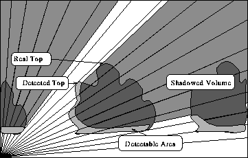
Figure 14: A cloud top detection of an optically thick cloud.
Lines of sight emerge from the lidar at the bottom-left corner of the box;
only a part of the cloud can be detected due to the strong signal extinction.
A portion of the volume scan is shadowed;
only the nearest surface can be measured by a lidar.
However, a scanning lidar
can look through holes in the cloud deck making
cloud top detection also possible for scattered, optically thick clouds.
This study derives a rough analytical
estimate of the detectable cloud height h
assuming 1) the horizontal scales of the clouds are approximately
equal to the CBL mean depth  , 2) the shape of
the clouds is square, 3) the clouds are evenly spaced
with a fractional cloud coverage C, and 4)
the lidar signal penetrates
, 2) the shape of
the clouds is square, 3) the clouds are evenly spaced
with a fractional cloud coverage C, and 4)
the lidar signal penetrates  deep into a cloud.
With these assumptions, the cloud coverage can be expressed as
deep into a cloud.
With these assumptions, the cloud coverage can be expressed as
where  is the minimum horizontal distance between clouds.
By solving
is the minimum horizontal distance between clouds.
By solving  from equation (3) and combining
it with assumptions 1--4 and the geometry shown in
Figure 14, the equation for detectable cloud height is
from equation (3) and combining
it with assumptions 1--4 and the geometry shown in
Figure 14, the equation for detectable cloud height is
The first term of this sum represents the path of
clear air between clouds; the second term is the vertical distance
the lidar backscatter signal can penetrate into a cloud.
The penetration depth of the VIL signal
into clouds is generally greater than 200 m
(see example Figure 11).
Equation (4) roughly estimates the limits of top detection
of optically thick clouds.
Even a moderate cloud coverage often prevents the VIL of
detecting the cloud tops.
For example, if  ,
,  , and
, and
 , then the tops of clouds less than 310 m thick
are detectable.
On the other hand, when cloud coverage is small, the cloud top
determination is only limited by the maximum elevation angle.
, then the tops of clouds less than 310 m thick
are detectable.
On the other hand, when cloud coverage is small, the cloud top
determination is only limited by the maximum elevation angle.
The maximum altitude of the most distant returns from clouds in a volume scan is used to define the cloud top altitude in this study. The last cloud return is marked by a rapidly falling signal after the cloud maximum return (see Figure 11). Because strong extinction in an optically thick cloud may cause a similar signature, the rest of the backscatter profile is checked for remaining backscatter. The ratio of lidar profiles penetrating through the cloud layer to all cloud top returns indicates the reliability of the cloud top estimate. If most of the lidar returns are blocked by the cloud layer, the cloud top estimate is almost certainly too low. When most of the lidar returns penetrate through the cloud layer, the highest cloud top estimate is reliable if there are remaining backscatter signals above the highest cloud return. When the RHI scans are inspected manually, the cloud top altitude is determined from the highest visible cloud structure. Figure 15 shows an RHI with a profile of the last cloud returns and a cloud top estimate. The cloud top estimate is higher than one would estimate from the RHI scan, since the cloud top is calculated using the whole volume scan, while one RHI scan shows only a fraction of the volume.
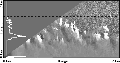
Figure 15: An RHI scan, a histogram of the last cloud returns
(white line), and estimated cloud top (black dashed line)
on August 2, 1989, at 12:00 CDT.
The automatic cloud top altitude estimates correlate with the manual estimates, as shown in Figure 16. A 15-minute maximum filter is applied both of the results to reduce statistical fluctuations due to sampling rate differences between the methods. The maximum filter is similar to running average filter, except the maximum of the sample window is used instead of the average. Boxes a--f mark selected cases where manual and automatic estimates differ substantially. The RHI scans for these cases are re-evaluated to explain the differences. Box a marks a point where a dust cloud rising up to 500 m caused the automatic method to fail. Boxes b-- f mark points where the differences are due to errors in the manual estimation. Boxes b and e mark points where human errors caused spurious values in the manual estimates. Boxes c, d, and f mark points where a higher cloud layer was missed by the manual method, since the vertical range of the display was set too small. After reinterpretation of RHI scans, the manual results marked in boxes b--f are within 50 m of the automatic estimates. In cases of partly transparent clouds, the manual method sometimes provides higher cloud top estimates, since it can detect even a faint cloud top ignored by the automatic method. When clouds are optically thick, both methods have the same visibility problems. The automatic method, however, samples each shot and thus provides statistically more stable estimates.
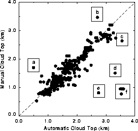
Figure 16: Cloud top altitude estimates using the manual method
vs. automatic method
from July 26 to August 11, 1989.
Box a marks a point where a dust cloud at 500 m
caused the automatic method to fail.
Boxes b and e
mark points where human error caused spurious values in the manual estimates.
Boxes c, d, and f mark points where a higher cloud layer
was missed by the manual method, since the vertical range of the display
was set too small.

