


The lidar backscatter echo from a cloud is detected as a strong
positive signal gradient (see Figure 11).
In this study, a cloud base echo is defined by the first
signal gradient limited by the data acquisition system.
The backscatter profiles are compressed to enable
real-time data transfer and saving into optical disks,
but the data compression method limits
the signal gradient to be less than 128 per data bin.
The loss of gradient information, however, does not contribute significant
error in backscatter profiles.
The gradient is calculated from three subsequent data points to
prevent misinterpreting noise-induced signal gradients as clouds.
To obtain representative cloud base estimates,
all shots in a volume scan are inspected for cloud echoes
and the lowest cloud echo defines the cloud base altitude.
This method provides the lowest cloud base altitude in
the 70 km scanning area.
As the VIL backscatter signal may include echoes from ground objects and
dust clouds, which are similar to cloud echoes,
every cloud echo below 200 m is omitted in the cloud calculations.
scanning area.
As the VIL backscatter signal may include echoes from ground objects and
dust clouds, which are similar to cloud echoes,
every cloud echo below 200 m is omitted in the cloud calculations.
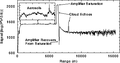
Figure 11: A VIL backscatter profile on July 26, 1989, at 10:48 CDT.
The elevation angle of the profile is 15 .
The irregularities below the first cloud return
are due to boundary layer aerosols.
Strong signal gradients characterize cloud echoes.
Insert graph shows aerosol fluctuations expanded by a factor of ten.
.
The irregularities below the first cloud return
are due to boundary layer aerosols.
Strong signal gradients characterize cloud echoes.
Insert graph shows aerosol fluctuations expanded by a factor of ten.
Figure 12 presents an RHI with a distribution profile of the first cloud return altitudes and an estimated cloud base which is measured within the resolution of the RHI scan. Clouds are good scatterers and are clearly visible in an RHI scan. However, when inspecting cloud bases from the RHI scans, the visual difference between thermals and clouds depends on the color enhancement selected for the display window. For example, some clouds in the figure seem to extend below the detected cloud base, since the chosen color enhancement shows backscatter from clouds and aerosol plumes with similar gray shades. An accurate estimation of the cloud base from the RHI scans requires a well-trained eye and careful setting of the color enhancement levels.
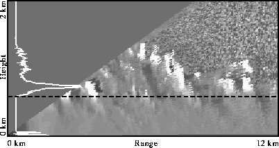
Figure 12: An RHI scan, a distribution profile
of the first cloud echoes
(white line), and estimated cloud base (black dashed line)
on August 2, 1989, at 12:00 CDT.
Bright structures represent cloud echoes.
The peak on the distribution profile
near the ground is caused by echoes
from dust clouds and ground objects (electric lines on a hill top
about 10 km from the lidar).
The automatic cloud base altitude estimates correlate well with the manually determined estimates. Manual estimation is performed by visually inspecting the RHI scans. Figure 13 presents the manual and automatic cloud base estimates for the 1989 FIFE experiment data. Only those cases with cloud coverage greater than 5% are analyzed. To reduce statistical fluctuations due to sampling differences, a 15-minute minimum filter is applied to the results. Most manual estimates are greater than or equal to automatic estimates. The manual method samples only about 1% of the RHI scans. Therefore, the lowest clouds in the are not likely to be sampled, which causes systematic overestimation. Statistical fluctuations on the order of 50 m are expected since the vertical resolution is limited by the elevation angle step size used in the volume scan. Boxes a--d mark regions where manual estimates are substantially higher than the automatic measurements. The RHI scans for these cases were visually re-examined to explain the differences. One sample in box c is due to a dust cloud rising up to 500 m, which caused the automatic method to fail. The other measurements in box c were made when there was a cloud layer above a few fair-weather cumulus clouds. In this case, the manual method is likely to miss the lower clouds due to insufficient sampling. If an inappropriate color enhancement is chosen in visual inspection of the RHI scans, aerosol plumes may be interpreted as clouds causing underestimated manual cloud base altitudes. This was the case in manual estimates in boxes e and f, which are more than 200 m lower than the automatic measurements. After reinterpretation of the RHI scans, the manual estimates in the marked boxes agree within 50 m with the automatic estimates.
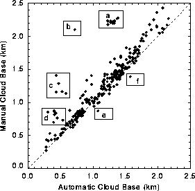
Figure 13: Cloud base altitude estimates using the manual method
vs. automatic method from July 26 to August 11, 1989.
Boxes a--d mark regions where the manual method missed the lower clouds
due to sparse sampling.
The highest sample in box c is due to an unusually high
dust cloud, which caused the automatic method to fail.
Box e marks a
sample where aerosol plumes were interpreted as
a cloud base in manual estimation.
Box f marks a sample where a plume top was misinterpreted as a cloud.
After re-evaluation, the manual estimates in boxes a--f agree within
50 m with the automatic estimates.