Return to the Publications.
Return to the Index.
Data was acquired at UW - Madison (96 N, 32 W) during simultaneous operation of HSRL and AERI systems; where each case includes a local CLASS radiosonde launch, see Table 3 for summary. HSRL data sets were typically scheduled to coincide with a satellite measurement (Landsat, NOAA-11 overpass, or GOES-8 scan). It should be noted that the UW Volume Imaging Lidar (VIL) (Piironen and Eloranta, 1995) was also in operation on various days.
|
Date Time (UTC) | Cloud Description |
| 17 Nov 1994 00:00-05:15 | Scattered cirrus, 7.5 to 12 km. |
| 25-26 Oct 1995 22:00-02:00 | Mostly clear, some thin scattered cirrus, 9-11 km. |
| 26 Oct 1995 14:15-19:00 | Thick ice cloud with base at 2 km,
turning to mixed phase at 4 km, then back to ice. |
| 9-10 Nov 1995 23:30-03:00 | Moderate cirrus, increasing in
optical thickness with decreasing cloud base. |
| 16-17 Nov 1995 22:00-02:45 | Clear skies turning cloudy with
non-uniform cirrus above a thin layer of water. |
| 2 Dec 1995 18:15-19:15 | 4 km water cloud with very uniform
base. Broken cirrus noted at 6 to 8 km. |
| 4 Dec 1995 15:15-20:00 | Broken cirrus, some water, very
non-uniform cloud. |
| 6 Dec 1995 16:15-23:00 | Broken, thin cirrus at 6-10 km, becoming clear. |
Derived results for each instrument are classified into two categories:
optical depth and brightness temperature. Optical depth calculations
yield a visible to infrared optical depth ratio, ![]() , that is
based on a uniform infrared cloud extinction cross-section. Brightness
temperature
measurements utilize a weighted visible cloud extinction cross-section
to derive
, that is
based on a uniform infrared cloud extinction cross-section. Brightness
temperature
measurements utilize a weighted visible cloud extinction cross-section
to derive ![]() . The goal is to demonstrate
the improvement gained in using the latter approach. This will illustrate
agreement between the instruments, while taking care to
differentiate inconsistencies due to errors associated with
instrument properties and measurements, atmospheric conditions, and
assumptions inherent in the incorporation of FASCOD3P and Mie model
simulations.
. The goal is to demonstrate
the improvement gained in using the latter approach. This will illustrate
agreement between the instruments, while taking care to
differentiate inconsistencies due to errors associated with
instrument properties and measurements, atmospheric conditions, and
assumptions inherent in the incorporation of FASCOD3P and Mie model
simulations.
In an effort to avoid confusion from multiple data sets, emphasis will be placed on results from two cases. Data from these days is useful in that the data acquisition period extended for several hours; and the observations were comprised of cirrus over a range of optical thickness and cloud base altitudes. Figures 10 through 13 illustrate the inverted HSRL aerosol backscatter and depolarization for these cases.
Figures 10 and 11 are inverted aerosol backscatter and depolarization, respectively, for data taken on 17 November 1994. Times are given in Universal Coordinated Time (UTC). Data is displayed in range-time-indicator (RTI) format, where the backscatter intensity scale is given in the color bar to the right of the image. Broken cirrus exists between 7 and 12 km, which provides a variable case for comparison against the AERI data. The feature within the bottom 2 km of the RTI is the planetary boundary layer. Large depolarization values, Figure 11, shows the clouds to consist entirely of ice particles. Depolarization remains near zero for spherical particles, which are seen within the humid boundary layer. This agrees with the radiosonde data which was previously shown in Figure 2.
Figures 12 and 13 are inverted aerosol RTIs for 9-10 November 1995. Two features make this an interesting case for study: the cloud base continues to decrease, nearly monotonically, over a 4 km range in a period of 2 hours; and the optical depth increases until it becomes opaque, with respect to the lidar, near 01:30 UTC. The moderate, boundary level aerosol layer depolarization near 1 km, Figure 13, indicates a transformation from spherical to non-spherical particles between 01:00 to 02:00 UTC.
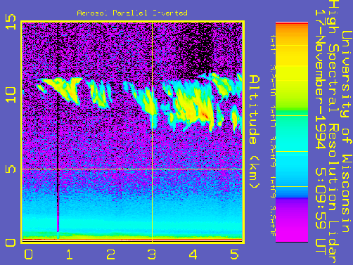
Figure 10: HSRL inverted aerosol backscatter signal for
17 November 1994. The abscissa indicates time in UTC format.
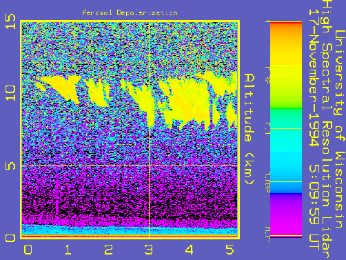
Figure 11: HSRL inverted aerosol depolarization
signal for 17 November 1994. The abscissa indicates time in UTC format.

Figure 12: HSRL inverted aerosol backscatter signal
for 10 November 1995. The abscissa indicates time in UTC format.

Figure 13: HSRL inverted aerosol depolarization
signal for 10 November 1995. The abscissa indicates time in UTC format.
Daniel DeSlover