


To verify consistency between the VIL wind profiles and traditional measurements, the VIL results are compared with: 1) data from eight National Center for Atmospheric Studies Portable Automatic Mesonet stations (PAMS) that provide half-hourly averaged, ground-based measurements [2], 2) radiosonde profiles measured by a team from Cornell University directed by Prof W. Brutsaert [2], and 3) aircraft-based Canadian National Aeronautical Establishments Twin Otter flight-path averaged measurements [67]. All comparison data is retrieved from the FIFE database [50]. Figure 32 provides an overview of the site locations and flight patterns on July 27, 1989. All measurements are done within a 20 km distance from each other. All weather stations are within 10 km from the VIL site and an average of 20 m lower than the VIL site.
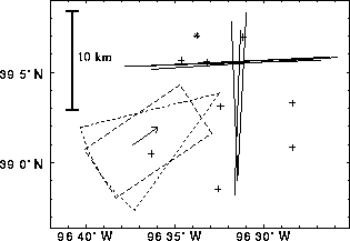
Figure 32: Site locations and
aircraft flight paths on July 27, 1989, from 11:00 to 12:00 CDT.
The 40 sector outlines the VIL scanning area.
The rectangle shows the
area where the VIL wind profiles are calculated.
The size and shape of the area compromise fine spatial resolution,
large area coverage, and reasonable computing time.
Lines show aircraft flight paths;
PAMS locations are marked with +;
the radiosonde launch site is marked with
sector outlines the VIL scanning area.
The rectangle shows the
area where the VIL wind profiles are calculated.
The size and shape of the area compromise fine spatial resolution,
large area coverage, and reasonable computing time.
Lines show aircraft flight paths;
PAMS locations are marked with +;
the radiosonde launch site is marked with  .
.
The arrow shows the wind direction. The radiosonde launch site is about six kilometers north of the VIL site.
Figure 33 compares hourly averaged VIL wind profiles,
radiosonde profiles, aircraft-based measurements, and
half-hourly averaged surface measurements
on July 27, 1989, from 11:00 to 12:00 CDT.
The cloud base altitude is 900 m;
the cloud top altitude is 1500 m;
the cloud coverage is about 35%.
Note, that due to wind the air parcels in the VIL scanning volume are
measured by the aircraft about half-hour later and they missed the
radiosonde site by about three kilometers.
The VIL wind profiles vary smoothly over the mixed layer
and cloud layer.
The  indicates less reliability above the cloud top
where the aerosol distribution is weaker,
although the method still gives some consistent results.
As expected, wind speeds decrease slightly towards the ground
showing friction effects.
The wind shows little directional shear in the convective boundary layer.
indicates less reliability above the cloud top
where the aerosol distribution is weaker,
although the method still gives some consistent results.
As expected, wind speeds decrease slightly towards the ground
showing friction effects.
The wind shows little directional shear in the convective boundary layer.
The surface measurements show the averages of eight weather stations
over a one-hour period.
The surface friction causes the averaged
ground winds to be slightly slower and backed
compared to the low-level VIL profiles.
For safety reasons, the VIL did not scan at the ground level,
causing a vertical gap between the VIL and PAMS measurements.
The wind measurements vary about 1 ms and
20
and
20 between stations, since
each PAMS is located at different points in the terrain.
Evidently, averaging several ground measurements together still
does not achieve the stability of area-averaged wind measurements.
between stations, since
each PAMS is located at different points in the terrain.
Evidently, averaging several ground measurements together still
does not achieve the stability of area-averaged wind measurements.
The discrepancy between radiosonde profiles and area-averaged VIL profiles is expected, since the radiosonde is sensitive to local wind variations due to turbulence. The radiosonde profiles suggest fairly strong directional wind shear at the top of the mixed layer and near the ground, while the VIL and aircraft measurements do not.
The VIL area-averaged wind profiles and aircraft flight-path averaged wind measurements are more representative than radiosonde wind profiles in mesoscale.
The aircraft flight-path averaged wind measurements agree with the VIL profiles. The largest deviations occur at the mixed layer top and near the ground. This is probably due to horizontal roll vortices, which are detected as trends in aircraft wind measurements. These eddies produce mostly vertical air motions in the middle of the mixed layer, where the VIL and aircraft measurements coincide better.
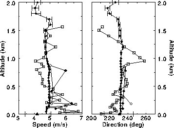
Figure 33:
Hourly wind profiles of the VIL compared with radiosonde profiles,
Twin Otter aircraft-based measurements, and PAMS ground measurements
on July 27, 1989, from 11:00 to 12:00 CDT.
The VIL results are marked with solid circles;
error bars represent estimated RMS errors.
Open squares represent
the radiosonde profiles which are vertically averaged to match the vertical
spacing of the VIL results.
The aircraft measurements are separated in East-West (open diamonds)
and South-North (solid diamonds) directed flights
and connected in temporal order starting from the lowest measurement.
Hourly averaged measurements
from eight PAMS are averaged (solid squares);
the error bars indicate the smallest and largest individual
PAMS measurements.
Figure 34 shows the correlation
between VIL results with  = 1
and simultaneous aircraft-based measurements.
A least-squares-fitted line through the data points
has a slope of 0.98
= 1
and simultaneous aircraft-based measurements.
A least-squares-fitted line through the data points
has a slope of 0.98 0.2
and an offset of 0.17
0.2
and an offset of 0.17 0.12 ms
 for wind speed,
and a slope of 1.01
for wind speed,
and a slope of 1.01 0.01 and an offset of 1.7
 1.9
1.9 for
direction.
The root-mean-square deviations between results are
about 1.0 ms
for
direction.
The root-mean-square deviations between results are
about 1.0 ms in speed and
12
in speed and
12 in direction.
The aircraft flights on
July 28, August 2, and August 3, were directed through the middle
of the VIL scan pattern.
Thus, the sampling of the aircraft and lidar were
more closely matched.
These results show smaller deviations from the mean value
in the VIL observations than in adjacent aircraft measurements,
suggesting that the VIL results are statistically more stable than the
aircraft measurements as a result of area averaging.
in direction.
The aircraft flights on
July 28, August 2, and August 3, were directed through the middle
of the VIL scan pattern.
Thus, the sampling of the aircraft and lidar were
more closely matched.
These results show smaller deviations from the mean value
in the VIL observations than in adjacent aircraft measurements,
suggesting that the VIL results are statistically more stable than the
aircraft measurements as a result of area averaging.
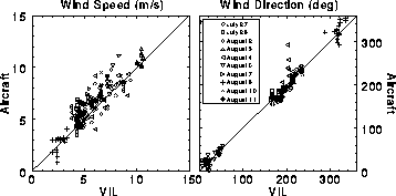
Figure 34:
Comparison of VIL and aircraft-based wind speed (left)
to direction (right)
measurements from the 1989 FIFE, from July 26 to August 11.