


Figures 20 through 22 summarize the CBL mean depths, cloud base altitudes, cloud top altitudes, and cloud coverages derived from the VIL boundary layer volume scans recorded during the FIFE program. These results are filtered with 15-minute filters to provide an overall presentation of daily boundary layer evolution. The CBL mean depths are filtered with a median filter to reduce temporary fluctuations. The cloud bases are filtered with a minimum filter to provide estimates of the lowest cloud bases. The cloud tops are filtered with a maximum filter to provide the highest cloud top estimates. The cloud coverages are filtered with an average filter to provide the mean of fractional cloud coverage.
When clouds are connected to the CBL, the CBL mean depth estimate should be interpreted as the altitude of maximum aerosol variation, as for example, on July 30, 1989, from 9:00 to 10:00 CDT, when the CBL mean depth estimate varies widely between cloud base and top. In cases of multiple cloud layers, the cloud base altitude represents the base of the lowest cloud layer, while cloud top altitude represents the top of the highest cloud layer. That is the case on August 5 and August 11, 1989, when there are occasionally more than 1 km differences between the cloud base and top altitudes. Clouds above 4 km are not observed from the volume scans, since the maximum elevation angle of the boundary layer scans limits the altitude range. Likewise, cloud coverage may be underestimated for cloud layers higher than 3.5 km.
If cloud coverage is high, the cloud top altitude estimates may be too low due to missing lines of clear sight. On overcast days, such as August 1--3, 1989, this probably happens due to optically thick clouds blocking the backscatter profiles. For example, on August 2, 1989, from 10:00 to 12:00 CDT, when the cloud coverage is close to 100%, the cloud heights remain obscure due to the limited backscatter signal penetration depth. When the cloud coverage is less than 70%, higher cloud heights are observed. This indicates that the actual cloud tops are seen at least once every fifteen minutes when cloud coverage is less than 70%. Unfortunately, comparison information does not exist to confirm this, since the VIL was the only instrument capable of measuring cloud top altitudes on the FIFE program.
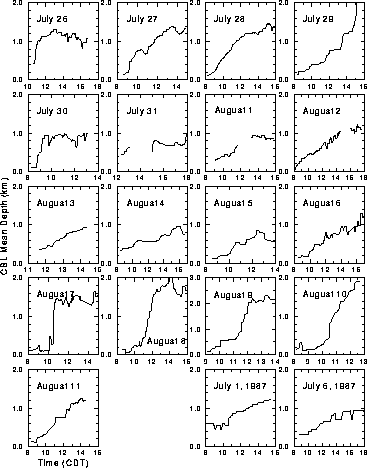
Figure 20: Summary of CBL mean depths for the 1987
(two graphs in the lower right corner) and 1989
(rest of graphs) FIFE.
Each graph shows CBL mean depth as a function local time.
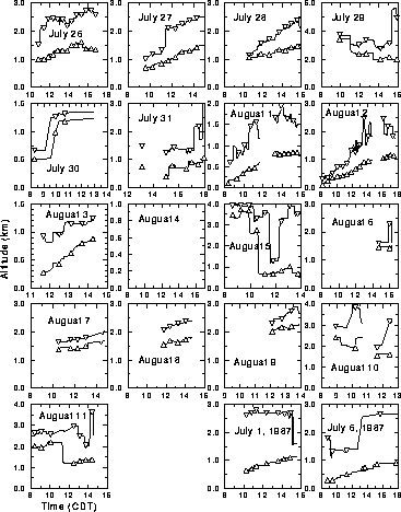
Figure 21: Summary of cloud bases and cloud tops
for the 1987 (two graphs in the lower right corner)
and 1989 (rest of graphs) FIFE.
Each graph shows lowest cloud base (lines with triangles up)
and highest cloud top (lines with triangles down)
as functions of local time.
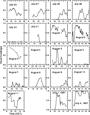
Figure 22: Summary of cloud coverages for the 1987
(two graphs in the lower right corner) and 1989 (rest of graphs) FIFE.
Each graph shows cloud coverage as a function of local time;
cloud coverage of 1 means overcast.