Return to the Index
or to the Lake-ICE.
University of Wisconsin Lidar Participation in the Lake-ICE experiment
The University of Wisconsin Volume
Imaging Lidar will be located in Sheboygan, Wisconsin, for
Lake-ICE. (Lake-Induced Convection Experiment.)
The city of Sheboygan is on the western
shore of Lake Michigan approximately 35 miles (58 km) north of
Milwaukee, 50 miles south of Green Bay, WI, and 100 miles NE of
Madison, WI. Click on the map below to see more detail of exactly where
we are located in Sheboygan. The approximate latitude and longitude of
the lidar site are: 43 deg 44.6 min North and 87 deg 42.0 min West.
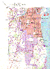 Quad map of southern Sheboygan (700 KB gif)
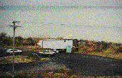 Photo of the VIL site in Sheboygan (looking SE) (72 KB gif)
Our objective during Lake-ICE is to collect 4-D lidar observations of
backscatter in the intense convective boundary layer (CBL) that forms
over Lake Michigan during cold-air outbreaks. The lidar is parked
just meters from the shore of the lake and we will scan downwind (over
the lake) to observe the first 15 km of the CBL. The depth of the CBL
over the lake during cold-air outbreaks increases as a function of
range from the upwind shore.
Photo of the VIL site in Sheboygan (looking SE) (72 KB gif)
Our objective during Lake-ICE is to collect 4-D lidar observations of
backscatter in the intense convective boundary layer (CBL) that forms
over Lake Michigan during cold-air outbreaks. The lidar is parked
just meters from the shore of the lake and we will scan downwind (over
the lake) to observe the first 15 km of the CBL. The depth of the CBL
over the lake during cold-air outbreaks increases as a function of
range from the upwind shore.
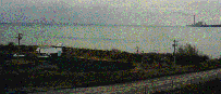 Photo of VIL and Edgewater power plant (looking SSE)
The Edgewater Power Plant is approximately 3.1 km south of the VIL site.
In addition to lidar observations of the marine boundary layer, we are
looking forward to observing the power plant plume.
Photo of VIL and Edgewater power plant (looking SSE)
The Edgewater Power Plant is approximately 3.1 km south of the VIL site.
In addition to lidar observations of the marine boundary layer, we are
looking forward to observing the power plant plume.
UW Lidar // Dec 2, 1997 // root@lidar.ssec.wisc.edu
 Quad map of southern Sheboygan (700 KB gif)
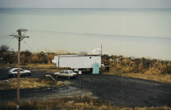 Photo of the VIL site in Sheboygan (looking SE) (72 KB gif)
Our objective during Lake-ICE is to collect 4-D lidar observations of
backscatter in the intense convective boundary layer (CBL) that forms
over Lake Michigan during cold-air outbreaks. The lidar is parked
just meters from the shore of the lake and we will scan downwind (over
the lake) to observe the first 15 km of the CBL. The depth of the CBL
over the lake during cold-air outbreaks increases as a function of
range from the upwind shore.
Photo of the VIL site in Sheboygan (looking SE) (72 KB gif)
Our objective during Lake-ICE is to collect 4-D lidar observations of
backscatter in the intense convective boundary layer (CBL) that forms
over Lake Michigan during cold-air outbreaks. The lidar is parked
just meters from the shore of the lake and we will scan downwind (over
the lake) to observe the first 15 km of the CBL. The depth of the CBL
over the lake during cold-air outbreaks increases as a function of
range from the upwind shore.
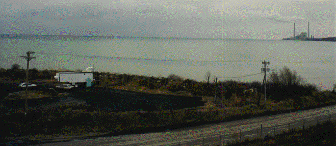 Photo of VIL and Edgewater power plant (looking SSE)
The Edgewater Power Plant is approximately 3.1 km south of the VIL site.
In addition to lidar observations of the marine boundary layer, we are
looking forward to observing the power plant plume.
Photo of VIL and Edgewater power plant (looking SSE)
The Edgewater Power Plant is approximately 3.1 km south of the VIL site.
In addition to lidar observations of the marine boundary layer, we are
looking forward to observing the power plant plume.