


The VIL and HSRL were aligned to view the same
cirrus clouds during CRSPE. This alignment allowed the cirrus clouds
to be used as a calibration target for the single channel VIL data.
This calibration scheme was possible because the HSRL unambiguously
determined the aerosol backscatter cross sections throughout
the depth of the cirrus cloud as described in Section 2.1. The HSRL
 were directly correlated to the VIL backscattered
signal for the simultaneously measured cirrus clouds. This was achieved
using a cirrus cloud
point comparison applied between the VIL backscattered signal and the
HSRL
were directly correlated to the VIL backscattered
signal for the simultaneously measured cirrus clouds. This was achieved
using a cirrus cloud
point comparison applied between the VIL backscattered signal and the
HSRL  .
.
Before the VIL backscattered signal could be calibrated, corrections had to be made to the VIL data. The VIL backscattered signal which was at the limit of detectability of the receiver had to be removed from the data set. If these system limited points were included in the VIL--HSRL comparison, an erroneous VIL signal calibration would result. The technique to remove the instrument limited data points is described in Appendix A. After the system limited points were removed from the data set, the VIL signal had to be corrected for angular dependencies in the data and/or possible temporal variations in the receiver (field of view changes or a change in gain of the avalanche photo--diode). This was accomplished by normalizing the VIL backscattered signal to a low level aerosol layer. This normalization technique, which required a spatially and temporally uniform aerosol layer to relate the VIL backscattered signal throughout time and space, is described in Appendix B.
After the corrections were made to the VIL data, a cirrus
cloud point comparison between the VIL corrected raw signal and the HSRL
 was achieved. The VIL data which viewed the clouds
over the HSRL were converted into an
altitude verses time profile (RTI) simulating the HSRL data set. The HSRL RTI
and VIL simulated RTI are shown in Figure 9. To create the
VIL RTI, the
backscattered signal was converted from spherical coordinates
into cartesian coordinates. The VIL data was then averaged in distance around
the HSRL site (24 km to the East of the VIL) to match the one minute
averaging of the HSRL profiles. The average wind speed at the cirrus
cloud heights was used with the averaging time of the HSRL data to
determine the VIL averaging distance (
was achieved. The VIL data which viewed the clouds
over the HSRL were converted into an
altitude verses time profile (RTI) simulating the HSRL data set. The HSRL RTI
and VIL simulated RTI are shown in Figure 9. To create the
VIL RTI, the
backscattered signal was converted from spherical coordinates
into cartesian coordinates. The VIL data was then averaged in distance around
the HSRL site (24 km to the East of the VIL) to match the one minute
averaging of the HSRL profiles. The average wind speed at the cirrus
cloud heights was used with the averaging time of the HSRL data to
determine the VIL averaging distance ( 2 km). Errors between
the positioning of the VIL and HSRL vertical profiles were caused by
misalignments between the VIL along wind scan plane and the
HSRL position (due to VIL scan angle errors). A cross correlation
between the HSRL RTI and VIL RTI
cloud points was calculated to find the best fit between the
two profiles. The position of the peak in the cross correlation was
compared to
the position of the peak of an autocorrelation of the HSRL RTI data
points. The difference between the peak positions for the two correlations
revealed shifts between the two RTIs. For the
19:29-21:20 GMT time period, the VIL data was shifted one point (60 m) in the
vertical and one point (one scan, 85 seconds or approximately 3 km) in the
horizontal compared
to the HSRL data. The horizontal and vertical shifts between the data sets
can result from: misalignment between the VIL scan direction
and the wind direction, scan angle errors, and/or inconsistent
time measurements between the two systems. The misalignment of the VIL scan
direction in relation to the wind direction can lead to significant errors if
there are large spatial variations in the cirrus cloud optical and structural
properties. The associated errors result from the differences in
the spatial averaging used to produce the HSRL and the VIL simulated vertical
profiles. The HSRL data were averaged along the wind axis while the
VIL data were averaged along the cirrus cloud scan axis; the two
profiles were produced from different sections of the
atmosphere. (The variations of the cirrus cloud
particles and the associated errors are discussed at the
end of this section.) Another problem can be the
misalignment of the VIL along wind scan. Slight scan angle miscalculations
will lead to relatively small distance errors. A 0.5
2 km). Errors between
the positioning of the VIL and HSRL vertical profiles were caused by
misalignments between the VIL along wind scan plane and the
HSRL position (due to VIL scan angle errors). A cross correlation
between the HSRL RTI and VIL RTI
cloud points was calculated to find the best fit between the
two profiles. The position of the peak in the cross correlation was
compared to
the position of the peak of an autocorrelation of the HSRL RTI data
points. The difference between the peak positions for the two correlations
revealed shifts between the two RTIs. For the
19:29-21:20 GMT time period, the VIL data was shifted one point (60 m) in the
vertical and one point (one scan, 85 seconds or approximately 3 km) in the
horizontal compared
to the HSRL data. The horizontal and vertical shifts between the data sets
can result from: misalignment between the VIL scan direction
and the wind direction, scan angle errors, and/or inconsistent
time measurements between the two systems. The misalignment of the VIL scan
direction in relation to the wind direction can lead to significant errors if
there are large spatial variations in the cirrus cloud optical and structural
properties. The associated errors result from the differences in
the spatial averaging used to produce the HSRL and the VIL simulated vertical
profiles. The HSRL data were averaged along the wind axis while the
VIL data were averaged along the cirrus cloud scan axis; the two
profiles were produced from different sections of the
atmosphere. (The variations of the cirrus cloud
particles and the associated errors are discussed at the
end of this section.) Another problem can be the
misalignment of the VIL along wind scan. Slight scan angle miscalculations
will lead to relatively small distance errors. A 0.5 error
in the scan angles (azimuth and/or elevation)
will lead to a 200 m error in scan position with regards to the HSRL profile.
This can easily account for the vertical shift
between the two data sets. A third problem resulted from differing
time records between the two systems. The HSRL clock
times were taken from the telephone. The times were given to the minute so
they were
error
in the scan angles (azimuth and/or elevation)
will lead to a 200 m error in scan position with regards to the HSRL profile.
This can easily account for the vertical shift
between the two data sets. A third problem resulted from differing
time records between the two systems. The HSRL clock
times were taken from the telephone. The times were given to the minute so
they were  30 seconds. The telephone time was then stored in a Whole
Sky Imager computer. Over a two week period, this clock drifted tens
of seconds.
Therefore the HSRL times are believed to be
30 seconds. The telephone time was then stored in a Whole
Sky Imager computer. Over a two week period, this clock drifted tens
of seconds.
Therefore the HSRL times are believed to be  1 minute. The VIL times
were set from the radio every day resulting in less than 5 seconds
of error. A 1 minute error between the two data sets
is approximately a 2 km error in the cirrus cloud
comparison. The shift of the VIL simulated RTI in relation
to the HSRL RTI can be accounted for by these errors.
1 minute. The VIL times
were set from the radio every day resulting in less than 5 seconds
of error. A 1 minute error between the two data sets
is approximately a 2 km error in the cirrus cloud
comparison. The shift of the VIL simulated RTI in relation
to the HSRL RTI can be accounted for by these errors.
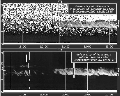
Figure 9: Comparison of cirrus clouds over Madison, Wisconsin from
18:08 to 23:20 GMT.
The x-axis is time and the y-axis is altitude.
The top picture is the HSRL RTI. The bottom picture is a VIL RTI 24 km
East of the VIL over the HSRL. The VIL RTI is a synthetic RTI created from
the VIL cirrus cloud scans to simulate the HSRL RTI. These two RTIs
were used for the cirrus cloud point comparison between the two lidar systems.
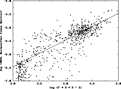
Figure 10: VIL--HSRL cirrus cloud data point comparison on December 1, 1989
from 19:29 to 21:20 GMT. The x-axis is the logarithm of the VIL range
squared corrected, energy normalized signal.
The y-axis is the logarithm of the HSRL aerosol backscatter cross sections.
Since the VIL signal was not corrected for losses due to attenuation,
only the bottom 1.5 km of the cirrus clouds was used in this comparison.
The cirrus cloud threshold value used in Section 3 is located at 3.48. A
straight line best fit to the cirrus cloud particles is also plotted.
The resulting profiles, HSRL RTI and the shifted VIL simulated
RTI, were compared on a
point by point basis. The result of this comparison can be seen in
Figure 10. A straight line of slope one which best fits the
cirrus cloud backscatter data was also plotted. This best fit
straight line was used to calibrate
the VIL data; it related the VIL backscattered signal directly to the
cirrus cloud aerosol backscatter cross sections per unit volume calculated
from the HSRL data. A one-to-one relationship was expected because of the
assumption that the scattering by the ice particles was independent of the
wavelength of the incident visible radiation. In Figure 10, the
VIL signal contains backscatter from both aerosols and molecules. For
this comparison, the molecular backscatter at 1064 nm was small
compared to backscatter from the cirrus cloud ice crystals
and was neglected. (The molecular signal was about twenty times smaller than
the background aerosol signal at the cirrus cloud heights for the
1064 nm wavelength radiation (see Section 4.2).)
The signal from non-cirrus aerosols can be seen at the lower end of the plot
in Figure 10. No VIL data had values less than
10 m
m sr
sr . This was a result of the dynamic
range of the VIL; data with values smaller than 10
. This was a result of the dynamic
range of the VIL; data with values smaller than 10 m
m sr
sr from a horizontal distance of 24 km could not be separated from
the noise in the data system.
from a horizontal distance of 24 km could not be separated from
the noise in the data system.
The VIL raw data in Figure 10 was not corrected for
attenuation. To avoid
attenuation problems in the initial
calibration, the point comparison was only performed on the bottom
1.5 km of the cirrus clouds where attenuation was assumed negligible.
This assumption would not be valid if the cirrus cloud was 1.5 km thick
(with a cloud base at 6 km), had an average
 of 1
of 1  10
10 m
m sr
sr , and was viewed at
an elevation angle of 4
, and was viewed at
an elevation angle of 4 out to 60 km. The optical depth would be 2
through the bottom 1.5 km of the cirrus clouds for this situation.
For the cirrus clouds in this study, the average cirrus
out to 60 km. The optical depth would be 2
through the bottom 1.5 km of the cirrus clouds for this situation.
For the cirrus clouds in this study, the average cirrus  (from Figure 13) was 1
  10
10 m
m sr
sr . This
would give an
optical depth of 0.2 only at far ranges (greater than 50 km) and low elevation
angles. So for a distance of 24 km the assumption of negligible
attenuation through the bottom 1.5 km of the cirrus clouds
(in the vertical) was valid.
. This
would give an
optical depth of 0.2 only at far ranges (greater than 50 km) and low elevation
angles. So for a distance of 24 km the assumption of negligible
attenuation through the bottom 1.5 km of the cirrus clouds
(in the vertical) was valid.
The bottom 1.5 km of the cirrus cloud seen by the VIL was calibrated using
the HSRL  . The result of the calibration can be seen in
Figure 11. Here the VIL signal at each point was transformed
into a
. The result of the calibration can be seen in
Figure 11. Here the VIL signal at each point was transformed
into a  . To calibrate the VIL data throughout the depth of
the cirrus clouds, corrections had to be made for signal loss due
to attenuation. The technique to correct for the attenuation in the VIL data
is described in Appendix C.
. To calibrate the VIL data throughout the depth of
the cirrus clouds, corrections had to be made for signal loss due
to attenuation. The technique to correct for the attenuation in the VIL data
is described in Appendix C.
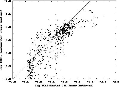
Figure 11: Same as Figure 10 except the calibrated VIL
 is compared to the HSRL
  . A one to one
line is plotted for reference.
. A one to one
line is plotted for reference.