


Stull [54] defines the atmospheric boundary layer as ``the part of the troposphere that is directly influenced by the presence of the earths surface, and responds to surface forcings with a time scale of about an hour or less.'' Figure 3 illustrates a typical daytime evolution of the atmospheric boundary layer in high pressure conditions over land. The solar heating causes thermal plumes to rise, transporting moisture, heat and aerosols. The plumes rise and expand adiabatically until a thermodynamic equilibrium is reached at the top of the atmospheric boundary layer. The moisture transferred by the thermal plumes forms convective clouds.
Drier air from the free atmosphere penetrates down, replacing rising air parcels. The part of the troposphere between the highest thermal plume tops and deepest parts of the sinking free air is called the entrainment zone. The convective air motions generate intense turbulent mixing. This tends to generate a mixed layer, which has potential temperature and humidity nearly constant with height. When buoyant turbulence generation dominates the mixed layer, it is called a convective boundary layer (CBL). The lowest part of the ABL is called the surface layer. In windy conditions, the surface layer is characterized by a strong wind shear caused by friction.
The boundary layer from sunset to sunrise is called the nocturnal boundary layer. It is often characterized by a stable layer, which forms when the solar heating ends and the radiative cooling and surface friction stabilize the lowest part of the ABL. Above that, the remnants of the daytime CBL form a residual layer. The nocturnal boundary layer may also be convective when cold air advects over a warm surface.
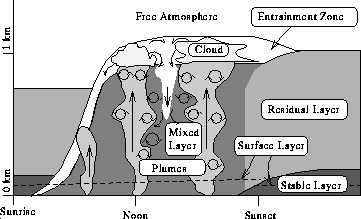
Figure 3: Schematic fair-weather atmospheric boundary layer structure
over land.
Under high pressure, divergence of air masses shallows the boundary layer. Typically, only fair-weather cumulus clouds are present. The analysis of the boundary layer structure is not usually that straightforward in the case of low pressure. The air parcels converge in low pressure in connection with updrafts, which transfer boundary layer air parcels high above the ground. The clouds may then grow to the top of the troposphere. This leads to extensive variations in the local boundary layer top. Thus, it becomes difficult to define a larger scale boundary layer depth.
The VIL scans reveal the structure of the atmospheric boundary layer. Figure 4 shows an RHI scan constructed from an elevation angle scan by mapping the data points measured in spherical lidar coordinates into cartesian range-height coordinates. The brighter areas indicate increased scattering from aerosols. Adiabatic cooling of the rising air parcels increases the relative humidity causing hygroscopic aerosols to grow and the scattering cross section of the aerosols to increase. Therefore, the thermal plumes appear as brighter structures attached to the ground. The free air, which is usually drier and has a smaller aerosol concentration, appears darker. As clouds are good scatterers, they are seen as bright objects in an RHI scan, allowing determination of the cloud base altitude. With a vertically pointing lidar, the cloud top altitudes can be determined only for optically thin clouds. However, angular scanning looks through possible holes in the cloud layer and often allows determination of the cloud tops of non-transparent clouds.
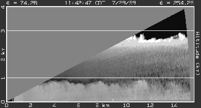
Figure 4: An RHI scan of the atmospheric boundary layer.
The bright area below 900 m shows the backscatter from
the aerosol-rich convective boundary layer.
The darker area from 900 m to 2400 m
shows lower backscatter from the free atmosphere.
The undulations of the top of the convective boundary layer
are due to thermals rising to the free atmosphere and clearer air sinking
to the CBL.
The brightest area at 2600 m shows
the backscatter from an altostratus cloud layer.
Light extinction in optically thick clouds
limits the lidar signal from penetrating the cloud layer.
This causes the cloud shadows in the volume scan
shown as the dark area above the cloud layer.