The University of Wisconsin Volume Imaging Lidar can detect three-dimensional elastic aerosol backscatter in large volumes [1]. Figure 1 shows a block diagram of the system.
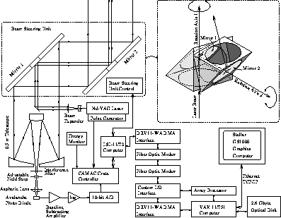
Figure 1: The VIL hardware used during the FIFE program.
The transmitted laser beam is aligned at the optical axis of the
receiver telescope.
The dual mirror scanning system can point the transmitter-receiver
at any direction in the sky.
A fiber optic modem between the data acquisition and controlling
computers enables fast data transfer.
A Stellar GS1000 graphics workstation is used for real-time
data visualization.
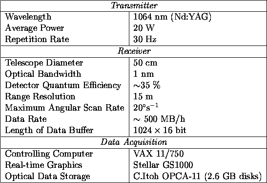
The transmitter employs a pulsed Nd:YAG laser aligned with the optical axis of the receiver. The receiver consists of a telescope, interference filter, and avalanche photo diode. Scanning is performed using a fast, computer controlled beam steering unit consisting of two flat rotating mirrors mounted at 45 angles at the optical axis of the transmitter-receiver system. An interactive user interface for the lidar is based on a VAX-11/751 computer, which controls the data acquisition system and preprocesses and records the data. A Stellar GS1000 graphics computer enables real-time monitoring of the data and system performance. The system is mounted in a semi-trailer, that has a water chiller and air conditioning to provide an adequate environment for the lidar and electronics. Only an external AC-power source is required for a full field operation. Table 1 summarizes the system specifications during the FIFE program.
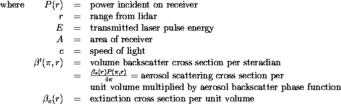
The high sensitivity of the VIL allows observations of inhomogeneities in the natural aerosol backscatter. The signal incident on the receiver is described by the single-scatter lidar equation
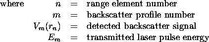
The dynamic range of the digitized signal is increased by amplifying the detected signal with a logarithmic amplifier. The data acquisition system has a 10 MHz sampling rate and a 10-bit digitizing resolution. Each backscatter profile is energy-normalized to compensate the output energy variations of the laser and corrected for inverse range-squared dependence. This signal is expressed as
Finally, the signal is saved in a compressed form on an optical
disk for later analysis
[1].
Since molecular absorption is
small compared to aerosol extinction at the 1064 nm
operation wavelength,
the measurement range depends mainly on the aerosol distribution and
range-squared dependence of the detected backscatter.
The high laser power, large telescope area, and
wide dynamic range of the receiver enable
detection of cirrus clouds up to 100 km from the lidar,
and boundary layer aerosols up to 30 km in a clear atmosphere.
Although the VIL can scan the whole sky,
special scanning patterns are used for different atmospheric studies.
For boundary layer studies, the VIL usually scans a 40
azimuthal and 15 elevational cone with a 15 m
radial, 0.5 azimuth, and 0.33 elevation angle resolution.
Figure 2 illustrates a typical
boundary layer volume scan pattern.
The VIL devotes about 3 minutes to scan this
100km volume consisting of about five million data points.
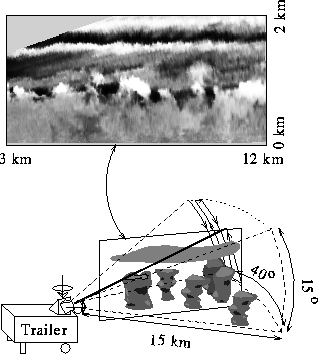
Figure 2: A schematic view of the VIL
in the boundary-layer scan mode.
The graph on the top shows an actual Range Height Indicator plane
calculated from the backscatter profiles of one elevational sweep;
the brighter areas indicate increased scattering from boundary
layer aerosols.