Volume Imaging Lidar Movie Samples 1987 - 1989
Return to Index.
Viewing these movies requires mpeg movie player. You may want to
change the preferences on your WWW browser to automatically load and
play the movies by selecting "MPEG" icon. Clicking on the thumbnail
image will show you a blowup of a sample GIF image. To control frame
rate and looping we use
VMPEG Lite 1.7
Download for MPEG viewing on Win95/98/NT platforms.
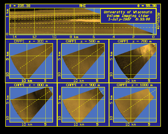
Six CAPPI's
Six Constant Altitude Plan Position Indicator (CAPPI) images (lower
images) and a Range Height Indicator (RHI) image (top image).
An RHI represents a vertical slice of backscatter from atmospheric
aerosols.
CAPPI's show horizontal backscatter field at different altitudes
(z).
Brighter areas indicate increased backscatter from the atmosphere.
Data were collected during First ISLSCP
(International Space Land Surface Climatology Project)
Field Experiment (FIFE) in
Kansas in summer 1987.
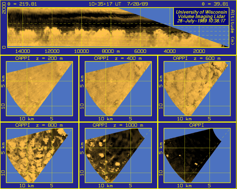
Morning Boundary Layer
The building of the boundary layer from 9:00 to 11:00 am, during
the FIFE II Field Experiment, July 28, 1989.
6-hour Convective Boundary Layer Movie
103 frames in 3.5-minute intervals showing the convective boundary layer
from 9:09 to 15:09, during the FIFE II Field Experiment, July 27, 1989.
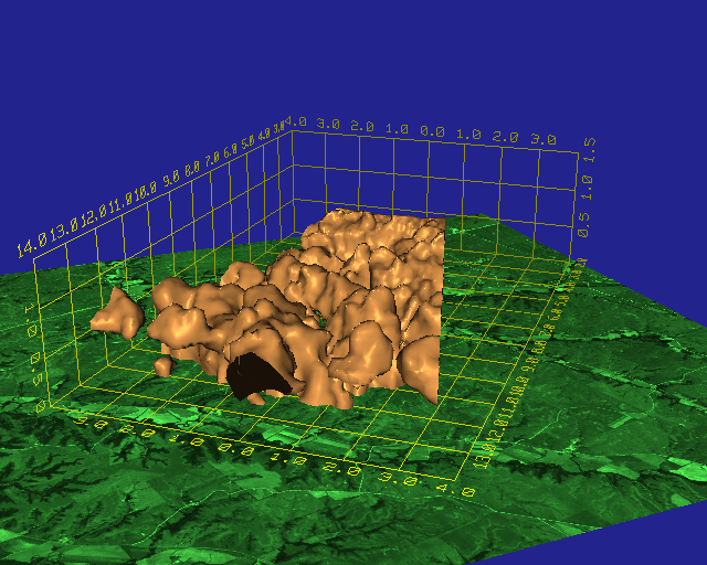
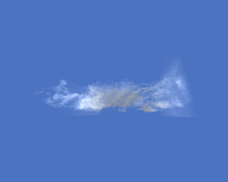
Clear Air Convection
Surfaces of constant backscatter return from boundary layer
aerosols showing clear air convection displayed above
a satellite image (green background).
Lidar data were collected during FIFE in summer 1987.
The terrain image was computed from a panchromatic SPOT
satellite image provided by the SPOT Image Corporation
(Copyright CNES 1987).
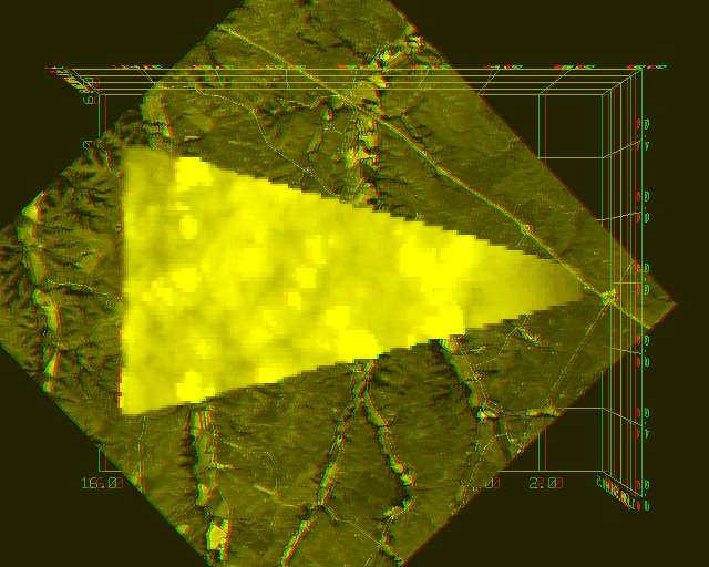
A View of the Convective Boundary Layer
A view of transparent boundary layer aerosol structures
calculated from boundary layer volume scans of the VIL.
Lidar data were collected during FIFE on July 1, 1987.
3D Stereo View of the Convective Boundary Layer
Stereo view of transparent boundary layer aerosol structures
calculated from boundary layer volume scans of the VIL.
Lidar data were collected during FIFE on July 1, 1987.
The terrain image was computed from a panchromatic SPOT
satellite image provided by the SPOT Image Corporation
(Copyright CNES 1987).
View with green-red (left-right eye, respectively) glasses.
A Top View of Fair Weather Cumulus Clouds
A view of fair weather cumulus clouds
calculated from boundary layer volume scans by the VIL.
Cumulus cloud movements are due to the wind.
Lidar data were collected during FIFE on August 8, 1989.
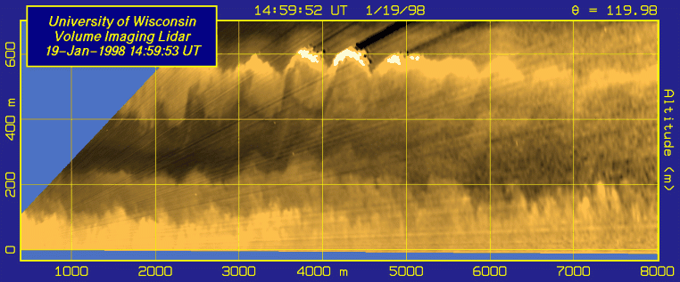
A landbreeze observed over Lake Michigan
This constant-altitude-azimuthal scan shows a density current of cold,
aerosol laden air flowing away from the Wisconsin shoreline over lake
Michigan in the face of a warm south-easterly onshore breeze. This was
observed with the VIL located at Sheboygan, Wisconsin on December 21,
1997 between 1524 and 1646 UTC (9:24 to 10:46 local). The scan plane is
approximately 5 m above the lake surface and the image area displayed
is 7 km (N-S) and 10 km (E-W). The lidar scans are seperated
by 24 seconds. A band of very light snow falling from a thin
stratus cloud enters the area near the end of the sequence. The
outflow velocity in the density current is less than 1 m/s while the
onshore south-easterly wind speed is approximately 3.5 m/s.
Gravity waves forming just off the Wisconsin shore of Lake Michigan
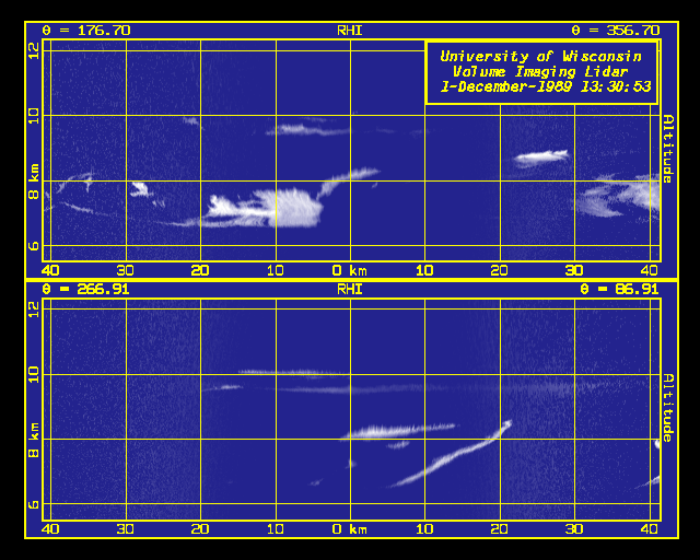
RHI Cirrus Scans
South-North (upper graph) and East-West (lower graph) RHI's showing
backscatter from cirrus clouds.
Data were collected during a Cirrus Remote Sensing Pilot Experiment (CRSPE)
near Pine Bluff, Wisconsin on December 1, 1989.
Fly around View of Cirrus
Visualization of cirrus clouds as seen from an airplane flying
around the cloud. The cirrus volume was created from subsequent RHI cirrus scans
which are corrected for scatterer movements due to wind.
This volume has been reconstructed from Volume Imaging
Lidar data taken at Pine Bluff, WI on December 1, 1989.
The pysical dimensions of the data volume are 234.4 km x 161.5 x 7.1 km
and the center of the volume is at 8.5 km altitude.
Fly by View of Cirrus
Visualization of cirrus clouds as seen from an airplane flying
through the cirrus. Same data volume as in the previous example.
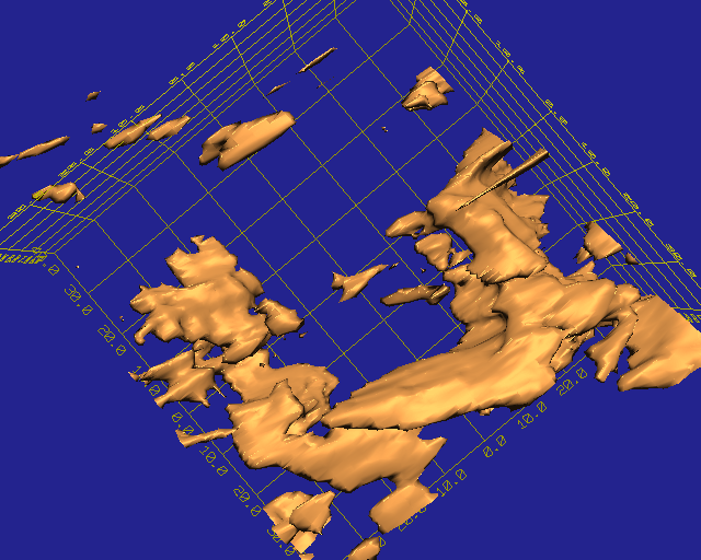
Cirrus Cloud Structures
Cirrus clouds are interpreted as solid objects showing the
cirrus structure.
Same data volume as in two previous examples.
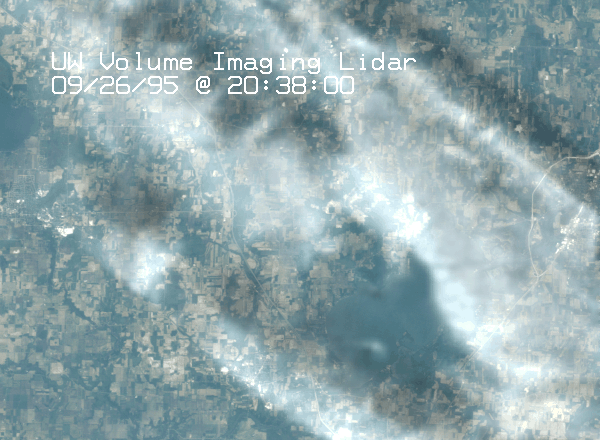
Top Down View
Raytraced approximate top-down view of cirrus clouds measured with the
VIL. This 3D scattering field is shown above a true color Landsat
image.
The view is generated by calculating the amount of light
scatter from a measured 3D backscatter field by using a single
scatter equation.
An approximate calibration of VIL data was performed by using
High Spectral Resolution Lidar measured optical parameters of the atmosphere.
Data were collected in Wisconsin on September 26, 1995.
Bottom Up View
Bottom-up view of cirrus clouds measured with the VIL.
The image is generated from the 3D scattering field by using
a single scattering ray trace program and an angle dependent phase function.
The phase function is taken from paper by Takano and Liou (J. Atm. Sci.,
46, 1, 3--19, 1989).
Same data as in the previous example.
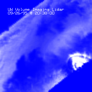
Fly by View of Cirrus 09/26/95
Visualization of cirrus clouds as seen from an airplane flying
through the cirrus. This volume has been reconstructed from Volume Imaging
Lidar data taken at Lake Koshkonong, WI during the time period of 20:14 GMT
to 20:38 GMT. The distance covered during the flight is 42 km.
480 x 360 Resolution
320 x 240 Resolution
Return to Index.